ARTICLE III -
DISTRICT
REGULATIONS
Section
301
- Classes of
Districts
For the purpose
of this
Ordinance the
Township of
Dingman is
hereby divided
into districts
which shall be
designated as
follows:
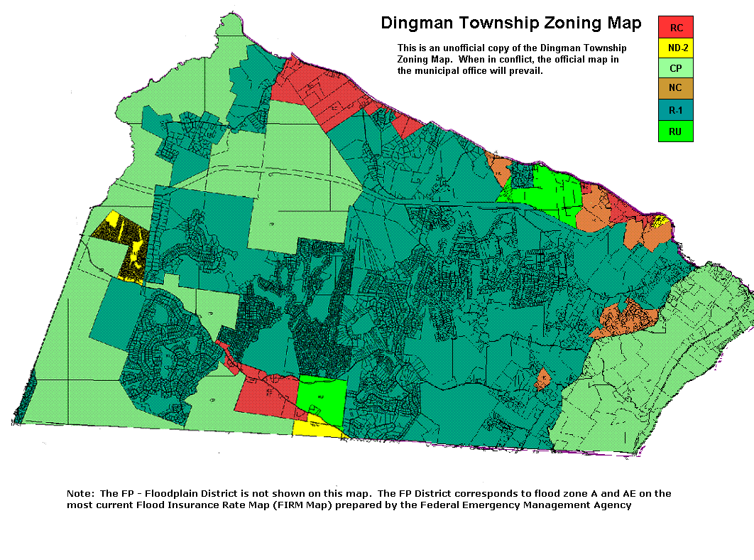
CP
Conservation and
Parks District
RU Rural
District
R-1 Low
Density
Residential
District
NC
Neighborhood
Commercial
ND2 Limited
Neighborhood
Development
District
RC Resort
Commercial
District
FP
Floodplain
District
The intent of
each District
and regulations
which shall
apply to each
are given in the
Schedule of Use
Regulations,
Section 305.
Back to Top
Section
302
- Zoning Map
The boundaries
of said
Districts shall
be shown upon
the map or maps
on display at
the Dingman
Township
Municipal
Building and
made a part of
this Ordinance
which shall be
designated the
"Dingman
Township
Official Zoning
Map". The same
map and all the
notations,
references and
other data shown
thereon are
hereby
incorporated by
reference into
this Ordinance
as if all were
fully described
herein.
Compilations of
the zoning maps
may be produced
by the Township
for general use,
but the official
zoning map will
control.
Back to Top
Section
303
- District
Boundaries
District
boundary lines
are intended to
follow or be
parallel to the
center line of
streets, streams
and railroads,
and lot or
property lines
as they exist on
a recorded deed
or plan of
record in the
Pike County
Recorder of
Deeds Office at
the time of the
enactment of
this Ordinance,
unless such
district
boundary lines
are fixed by
dimensions as
shown on the
Zoning Map. In
any case of
uncertainty the
Dingman Township
Board of
Supervisors in
consultation
with the
Planning
Commission shall
interpret the
intent of the
map as to
location of
District
boundaries. The
boundaries of
the CP District
will usually be
the same as the
boundaries of
the State
Forest, State
Gamelands, State
Park and
Delaware Water
Gap National
Recreation Area
lands within the
Township but may
include some
parcels in
private
ownership.
Back to Top
Section
304
- District
Regulations -
Generally
District
regulations are
of three types:
Use Regulations,
Development
Standards and
Special
Performance
Standards; all
which shall
apply to any
proposed new
use, expansion
of an existing
use or change of
use of land in
Dingman
Township.
Back to Top
Section
305
- Use
Regulations
Use regulations
and statements
of intent for
each District
are provided in
the following
Schedule of Use
Regulations.
***CLICK
HERE TO VIEW
USE CHART***
***
CLICK HERE TO
VIEW ZONING MAP
***
Back to Top
Section
306
- Development
Standards
The Development
Standards which
apply to each
District include
minimum lot
sizes, minimum
average widths,
minimum lot
depth, yard
requirements,
maximum lot
coverage, and
maximum height.
These standards
vary among
Districts. The
schedule of
Development
Regulations on
the following
page provides
standards for
each district.
|
Dingman
Township
Zoning
Ordinance
-
Schedule
of
Development
Regulations |
|
Criteria |
CP
District |
RU
District |
R-1
District |
NC
District |
ND-2
District |
RC
District |
|
Central
or
On-lot
Utilities |
On-lot
Sewage
or Water |
Central
Sewage
and
Water |
On-lot
Sewage
or Water |
Central
Sewage
and
Water |
On-lot
Sewage
or Water |
Central
Sewage
and
Water |
On-lot
Sewage
or Water |
Central
Sewage
and
Water |
On-lot
Sewage
or Water |
Central
Sewage
and
Water |
|
|
|
Minimum
lot area
per
dwelling
or use |
1 acre |
1 acre |
0.5 acre |
1 acre |
0.5 acre |
1 acre |
0.5 acre |
1 acre |
0.5 acre |
1 acre |
0.5 acre |
|
Minimum
average
lot
width |
150 feet |
150 feet |
100 feet |
150 feet |
100 feet |
150 feet |
100 feet |
150 feet |
100 feet |
150 feet |
100 feet |
|
Minimum
front
yard |
50 feet |
50 feet |
40 feet |
40 feet |
40 feet |
50 feet |
40 feet |
50 feet |
40 feet |
50 feet |
40 feet |
|
Minimum
side
yard |
50 feet |
25 feet |
15 feet |
15 feet |
15 feet |
15 feet |
15 feet |
15 feet |
15 feet |
25 feet |
15 feet |
|
Minimum
side
yards
(both
sides) |
100 feet |
50 feet |
30 feet |
30 feet |
30 feet |
50 feet |
30 feet |
50 feet |
30 feet |
50 feet |
30 feet |
|
Minimum
rear
yard |
50 feet |
50 feet |
25 feet |
25 feet |
15 feet |
25 feet |
15 feet |
10 feet |
15 feet |
50 feet |
25 feet |
|
Maximum
Building
Height |
35 feet |
50 feet |
50 feet |
35 feet |
35 feet |
50 feet |
50 feet |
50 feet |
50 feet |
50 feet |
50 feet |
|
Maximum
lot
coverage |
10,000
sq. ft.
or 20%
whichever
is
greater |
10,000
sq. ft.
or
50%
whichever
is
greater |
10,000
sq. ft.
or
50%
whichever
is
greater |
10,000
sq. ft.
or 20%
whichever
is
greater |
10,000
sq. ft.or
20%
whichever
is
greater |
10,000
sq. ft.
or
50%
whichever
is
greater |
10,000
sq. ft.
or
50%
whichever
is
greater |
10,000
sq. ft.
or
50%
whichever
is
greater |
10,000
sq. ft
or
50%
whichever
is
greater |
10,000
sq. ft.
or
50%
whichever
is
greater |
10,000
sq. ft.
or
50%
whichever
is
greater |
|
Notes
applicable
(see
below) |
1,3,4 |
3,4 |
3,4 |
3,4 |
3,4 |
3,4 |
3,4 |
2,4 |
2,4 |
3,4,5 |
3,4,5 |
|
Notes:
1)
Development
regulations
for the
CP
District
shall
apply to
all uses
in the
FP
(Floodplain
Protection)
District.
2)
Central water supply and off-site sewage disposal facilities are required for principal permitted uses. Recreational Vehicle sites – 9,000 sq. ft. The setback lines for the placement of any structure on a recreational vehicle campsite including but not limited to: recreational vehicles, tents, trailers, cars, trucks or other motorized vehicles used for camping, accessory buildings (which may not be used for human habitation), decks, landings, patios, gazebos, or anything other than natural vegetation shall be: fifteen (15) feet from the front lot line; fifteen (15) feet from the back lot line; seven and one-half (7 ½”) feet from the side lot lines; and fifty (50) feet from the top of the bank of any body of water (lake, stream, brook, etc.). No part of the recreational vehicle, including slide outs, tip outs, etc., may encroach into the setback area. The total of both side yards shall be no less than fifteen (15) feet and no recreational vehicle or structure that exceeds fifteen (15) feet in height may be placed on the lot.
For a
corner
lot the
rear
yard
opposite
the road
on which
the lot
has the
most
frontage
may be
reduced
by 50%. A lot used for transient camping may obtain a permit for such use with a designated pad area for the placement of structures. The entirety of any structure, including any camping structures, shall be within the confines of the pad at all times after installation. Seasonal camping shall not be considered transient. The property owner shall be required to show the zoning officer adequate evidence of the location of lot lines (including a survey if deemed necessary by the officer) before placing any such structures. The placement of any such structure shall require a zoning permit under this ordinance. Any owner may apply for a certificate of non-conforming use for any structure previously placed that would otherwise be in violation of this provision within eighteen (18) months of the date of enactment. Thereafter, any such structures shall be considered to be in violation of this provision.
3)
Barns,
silos
and
similar
farm
buildings
are
exempt.
4)
Residential
structures
shall
meet R-1
District
standards,
regardless
of the
zoning
district.
5)
See §
435 for
Mixed-Use
Project
development
standards |
Section
307
- Floodplain
Development
1. Definition of
Floodplain
Areas: The
identified
floodplain area
shall be any
area of Dingman
Township ,
subject to
flooding as
identified on a
Flood Insurance
Rate Map (FIRM)
issued by the
Federal
Emergency
Management
Agency or its
successor agency
and dated
December 4,
1985, or any
subsequent
revision. Flood
elevations will
be determined in
specific
instances by a
combination of
this map with
U.S.D.A. Soil
Conservation
Service data,
U.S.G.S.
mapping and
other floodplain
information
sources. The
identified
floodplain area
may be revised
or modified by
the Board of
Supervisors
where studies or
information
provided by
qualified agency
or person
document a need
for such
revision.
However, prior
to any such
change, approval
must be obtained
from the Federal
Emergency
Management
Agency or its
successor
agencies.
2. Prohibition
of Development:
No new
manufactured
housing unit,
structure,
substantial
improvement to
an existing
structure (as
defined by the
Pennsylvania
Floodplain
Management Act),
or other
development
shall be
permitted within
any Zone "A" or
"AE" flood area
on Dingman
Township's FIRM
excepting uses
not involving
permanent
structures, as
provided in
Section 307.3(5)
hereof.
Provided,
however, that
bridges,
culverts or
other crossings
of bodies of
water, shall be
permitted as
conditional
uses.
Bridges,
culverts or
other crossings
owned and
maintained by
the federal,
state, county or
municipal
government shall
be exempt from
the requirement
to obtain a
permit.
They shall,
however, submit
to the Township
proof that they
have received
all necessary
state permits
for any such
project before
initiating
construction. A
proposed
replacement of
an existing
crossing
structure shall
either be equal
to or exceed the
capacity of the
structure to be
replaced.
New structures
shall meet all
applicable
standards.
Existing
manufactured
housing units in
the floodplain
area may be
replaced but the
new manufactured
housing units or
any additions to
existing homes
shall be
anchored to
resist
flotation,
collapse, or
lateral movement
by providing
over-the-top and
frame ties to
ground anchors.
a) over - the -
top ties shall
be provided at
each of the four
(4) corners of
the manufactured
housing unit,
with two (2)
additional ties
per side at
intermediate
locations for
units fifty (50)
feet or more in
length, and one
(1) additional
tie per side for
units
less than
fifty (50) feet
in length.
b) frame ties
shall be
provided at each
corner of the manufactured
housing unit,
with five (5)
additional ties
per side at
intermediate
locations for
units fifty (50)
feet or more in
length, and four
(4) additional
ties per side
for units less
than fifty (50)
feet in length.
c)
all components
of the anchoring
system shall be
capable of
carrying a force
of four thousand
eight hundred
(4800) pounds.
d)
the stands or
lots shall be
elevated on
compacted fill
so that the
lowest floor of
the mobile home
will be at or
above the
one-hundred
(100) year
flood.
Evacuation plans
for manufactured
housing
parks indicating
alternate
vehicular access
and escape
routes shall be
submitted to the
Township Board
of Supervisors
for review and
approval. Such
evacuation plans
shall be
evaluated in
consultation
with the
Pike
County Emergency
Management
Agency and, if
necessary,
revised so as to
provide for safe
means of access
and escape.
New and
replacement
water supply
systems within
identified
floodplain area
shall be
designed to
minimize or
eliminate
infiltration or
flood waters of
the 100 year
flood.
Regardless of
the other data
no new
construction
shall be located
within the area
measured fifty
(50) feet
landward from
the top-of-bank
of any
watercourse.
No encroachment,
alteration or
improvement of
any kind shall
be made to any
watercourse
until all
adjacent
municipalities
which may be
affected by such
action have been
notified by the
Township and
until all
required permits
or approvals
have been first
obtained from
the Department
of Environmental
Protection Bureau
of Dams and
Waterway
Management.
In the event
that state
regulations
require the
issuance of a
Township permit
prior to the
application for
any state
permit, this
section is
hereby waived. In
addition, the
Federal
Insurance
Administrator or
Director of any
successor Agency
and the
Pennsylvania
Department of
Community
Affairs, Bureau
of Community
Planning, or its
successor
agency,should
be notified by
the Township
prior to any
alteration or
relocation of
any watercourse.
3. Procedures:
No zoning permit
shall be issued
anywhere within
the Township
until a review
of the proposed
activity is made
to assure all
necessary
permits have
been received
including any
which may be
required under
Section 404 of
the Federal
Water Pollution
Control Act
(Army Corps of
Engineers Permit
Program). In the
event that state
regulations
require the
issuance of a
Township permit
prior to the
application for
any state
permit, this
section is
hereby waived. All
subdivision
proposals or
proposals for
development
involving more
than five acres
of land shall
include base
flood elevation
data. Such data
should be
developed by a
professional
engineer,
hydrologist, or
other
technically
qualified
individual using
Soil
Conservation
Service, Army
Corps of
Engineers or
other comparable
data or by
applying one of
the techniques
recommended by
the Pennsylvania
Department of
Community
Affairs. The
Zoning Officer
and/or Planning
Commission will
review all
permit
applications to
determine
whether proposed
building sites,
subdivisions and
developments
will be
reasonably safe
from flooding
(outside the 100
year floodplain)
and otherwise
meet the
standards of
this section. No
permits will be
issued until and
unless such a
determination is
made.
4. Permitted
Uses: The
permitted uses
within the
floodplain shall
be limited to
the following:
(1)
Timber
harvesting
(2)
Commercial
nurseries, but
not including
any permanent
structures
(3)
Agricultural
uses, but not
including any
intensive
livestock
operations or
permanent
structures
(4) Golf
courses, but not
including any
permanent
structures
(5)
Public parks and
playgrounds, but
not including
any permanent
structures
(6)
Boating access
areas not
including any
permanent
structures shall
be considered
conditional uses
An existing
structure within
a designated FP
Floodplain
Development
District may,
subject to
Special
Exception
approval, and
provided no
changes to the
footprint of the
structure or
increases in the
floor area are
involved, be
converted to an
office or bed
and breakfast
establishment or
day care
facility.
5. Floodplain
Variances: In
reviewing any
requests for a
floodplain
variance the
Zoning Hearing
Board shall,
prior to
approving any
such request,
determine:
(1) all
the requirements
for a variance,
set forth in
Section 710,
have been met.
(2)
ensure the
granting of the
variance will
not result in
any increase of
flood heights,
additional
threats to
public safety,
extraordinary
public expenses,
creation of
nuisances, cause
fraud on or
victimization of
the public or
conflict with
any other
applicable local
or State
ordinances and
regulations.
6.
Documentation:
In all variance
requests:
(1) the
applicant shall
provide
documentation,
certified by a
professional
engineer or
architect,
clearly
demonstrating
the proposal
will not result
in any increase
of flood heights
or additional
threats to
public safety.
(2)
the
applicant shall
submit to the
Pennsylvania
Department of
Community
Affairs -
Floodplain
Management
Division and the
Federal
Emergency
Management
Agency copies
of such
documentation,
certified by a
professional
engineer or
architect, for
the purpose of
review and
comment. Copies
of such
comments shall
be submitted as
part of the
variance
request. A
hearing for a
variance request
shall not be
scheduled until
the applicant
has received the
Department of
Community
Affairs comment.
If granted, a
variance shall
involve only the
least
modification
necessary to
provide relief.
If is should
become necessary
to grant any
variance, the
applicant shall
be required to
comply with all
applicable
requirements of
the National
Flood Insurance
Program
Regulations
including the
requirements for
floodproofing,
anchoring and
elevation. The
applicant must
also comply with
any other
requirements
considered
necessary by the
Township.
In granting any
variance the
Zoning Hearing
Board shall
attach whatever
reasonable
conditions or
safeguards it
considers
necessary in
order to protect
the public
health, safety
and welfare and
to achieve the
objective of
this Ordinance.
Whenever a
variance is
granted the
applicant is
hereby notified
that the
granting of the
variance may
result in
increased
premium rates
for flood
insurance and
that such
variances may
increase the
risk to life and
property.
A
complete record
of all variance
requests and
related
incidents shall
be maintained by
the Township. In
addition, a
report of all
variances
granted during
the year shall
be included in
an annual report
to the Federal
Emergency
Management
Agency or its
successor.
Notwithstanding
any of the
above, however,
all structures
shall be
designed and
constructed so
as to have the
capability of
resisting the
100 year flood
in accordance
with the
provisions of
the Corps of
Engineers
publication
entitled
"Flood-proofing
Regulations -
June 1972".
Notwithstanding
the rights of
any applicant to
apply for
variance (in
special
instances) no
variance shall
be granted which
will allow the
following
activities and
development to
locate within a
floodplain area,
as they present
a special hazard
to the health
and safety of
the public:
a.
Hospitals
(public or
private)
b.
Nursing homes
(public or
private)
c. Jails
or prisons
d.
Individual
mobile homes,
new mobile home
parks, mobile
home
subdivisions and
substantial
improvements
thereto, as well
as to individual
mobile homes
e. Any
new or
substantially
improved
structure which
will be used for
the production
or storage of
any of the
following
dangerous
materials or
substances or
which will be
used for any
activity
requiring the
maintenance of a
supply (more
than 550 gallons
or other
comparable
volume or any
amount of
radioactive
substances) of
any of the
following
dangerous
materials or
substances on
the premises:
1) Acetone
2) Ammonia
3) Benzene
4) Calcium
carbide
5) Carbon
disulfide
6) Celluloid
7) Chlorine
8)
Hydrochloric
acid
9)
Hydrocyanic acid
10) Magnesium
11) Nitric acid
and oxides of
nitrogen
12) Petroleum
products
(gasoline, fuel
oil, etc.)
13) Phosphorus
14) Potassium
15) Sodium
16) Sulfur and
sulfur products
17) Pesticides
(including
insecticides,
fungicides, and
rodenticides)
18) Radioactive
substances,
insofar as such
substances are
not otherwise
regulated
7. Abrogation
and Greater
Restrictions:
This Ordinance
supersedes any
other
conflicting
provisions which
may be in effect
in identified
floodplain
areas. However,
any other
ordinance
provisions shall
remain in full
force and effect
to the extent
that those
provisions are
more
restrictive. If
there is any
conflict between
any of the
provisions of
this Ordinance,
the more
restrictive
shall apply.
8. Documents:
Copies of
documents
referenced
herein shall be
available from
the Township
Zoning Officer.